

Unprecedented floods in Feni-Comilla and Eastern Bangladesh: Examining causes and accountability
Dr Md Ataur Rahman
Publish: 31 Aug 2024, 10:13 PM
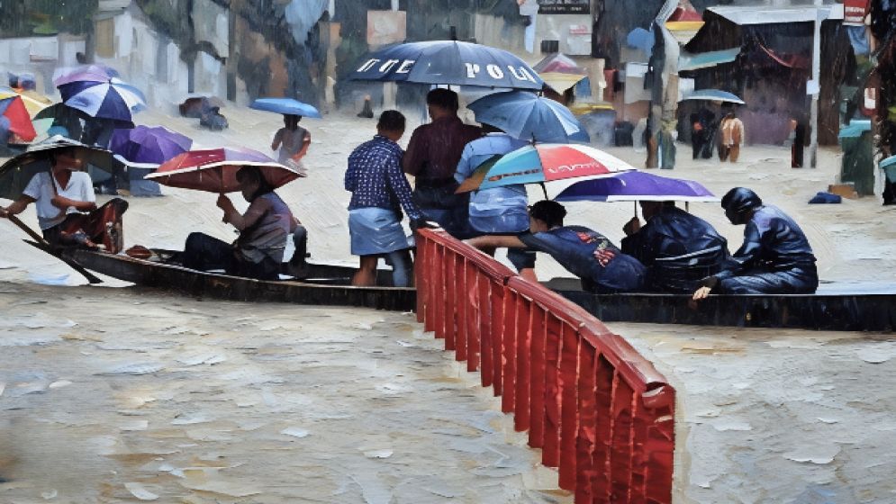
Since August 21, catastrophic floods have ravaged eastern and southeastern Bangladesh, impacting districts such as Moulvibazar, Habiganj, Brahmanbaria, Comilla, Feni, Chattogram, Khagrachari, Noakhali, and Lakshmipur.
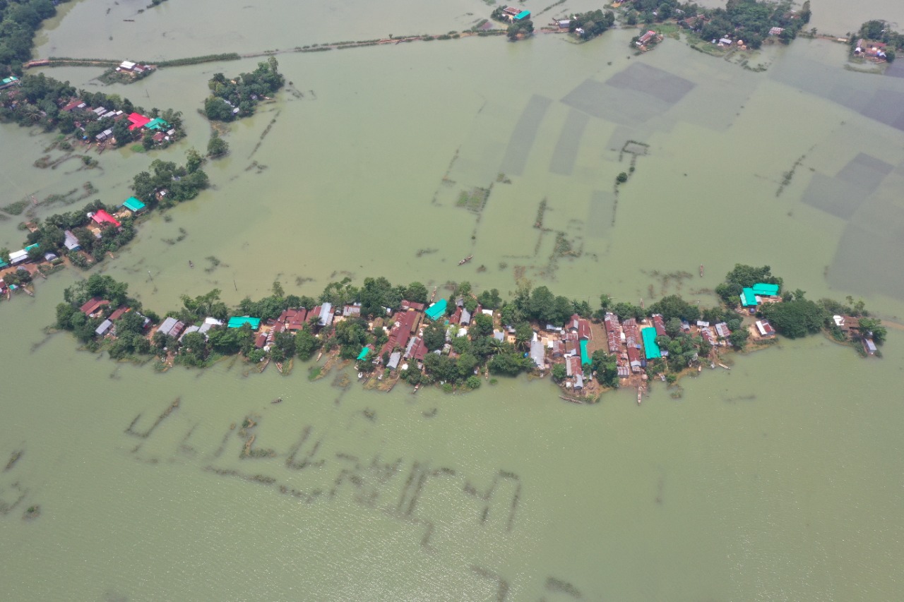
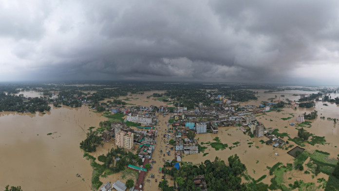
Feni and Comilla are experiencing their worst floods in 36 years. The Ministry of Disaster Management and Relief reports 23 deaths and an estimated 5.7 million people affected as of August 26.
A widespread relief effort is underway, with the interim government, local officials, military, coast guard, students, organizations, and citizens collaborating to rescue those stranded and provide essential food supplies.
The floods have also caused significant devastation in the neighboring Indian state of Tripura, with at least 31 deaths and 1.7 million people stranded as of August 26. This marks Tripura's worst flood in over three decades.
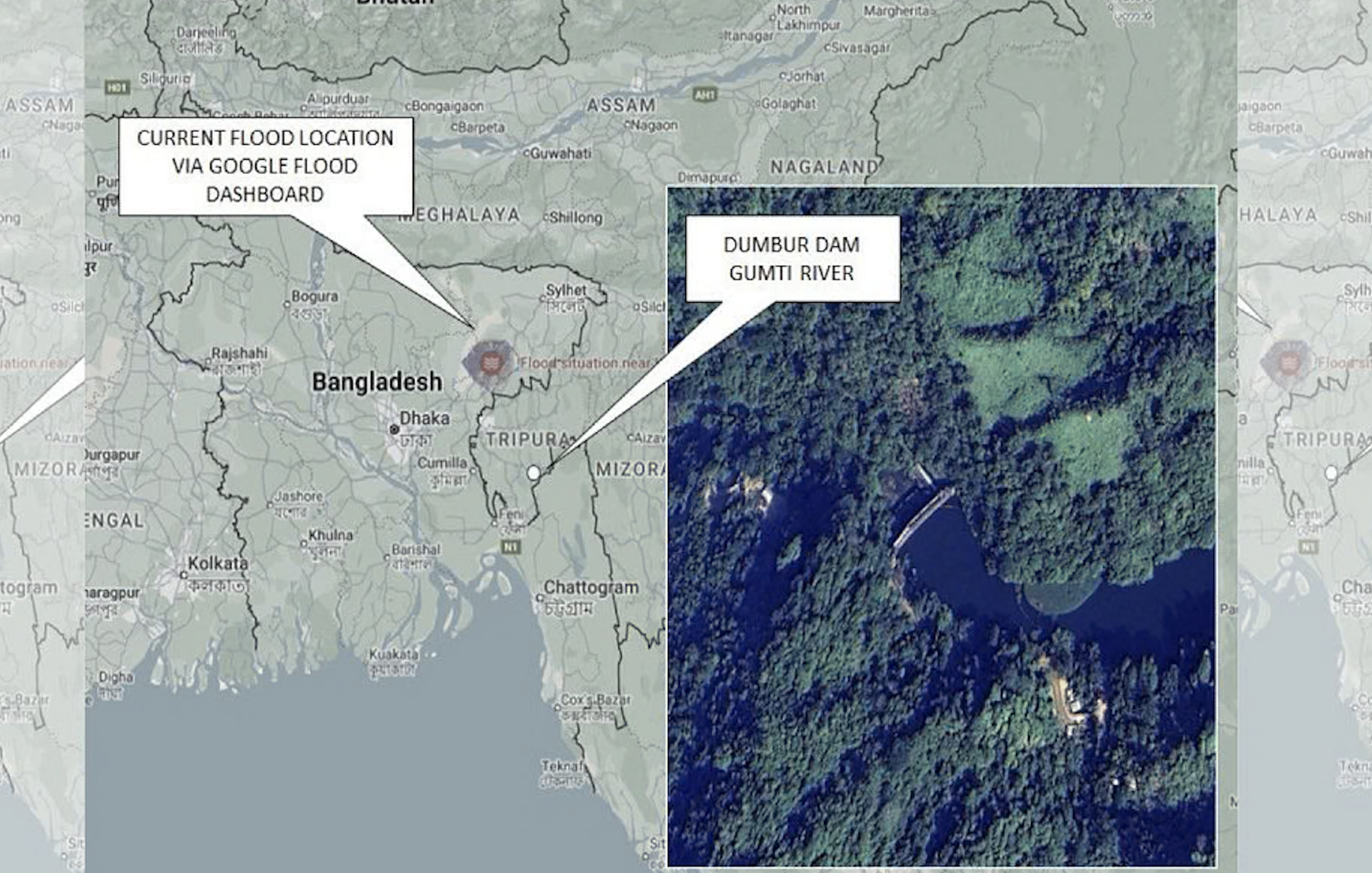
While the people of Bangladesh extend aid and prayers to flood victims, social media is rife with speculation and misinformation about the flood's causes and culpability. Accusations include the release of water from India's Dumboor Dam on the Gomti River.
This article seeks to examine the facts surrounding the current flooding in Feni, Comilla, and adjacent areas, which are typically less susceptible to flooding.
To gain a deeper understanding, we must consider the geographical location, river systems, drainage infrastructure, and recent weather patterns in the region.
Geographical Location and Rivers
Tripura, a northeastern Indian state bordering eastern Bangladesh, is largely mountainous with peaks reaching 3,000 feet.
It shares its border with seven Bangladeshi districts: Moulvibazar and Habiganj to the north, Brahmanbaria and Comilla to the west, Feni and Chattogram to the south, and Khagrachari to the east.
Numerous rivers originate in Tripura's hills and flow into Bangladesh, accounting for 15 of the 54 international rivers entering Bangladesh from India. These include the Juri, Manu, Dhalai, Longla, Khowai, Sutang, Sonai, Howrah, Bijini, Salda, Gomti, Dakatia, Sillongia, Muhuri, and Feni.
Six of these rivers flow north, six flow west, and three flow south into Bangladesh. Tripura's mountainous topography means rainfall quickly drains into Bangladesh via these 15 rivers, potentially causing flash floods in Tripura and the seven adjacent Bangladeshi districts if the rainfall is particularly heavy.
Besides Tripura, heavy rainfall in the hilly regions of Meghalaya, situated north of Sylhet-Sunamganj, can also trigger flash floods in Bangladesh. The Sylhet-Sunamganj area experienced severe flash floods in May and June this year.
Irrespective of the entry point, floodwater eventually flows through Bangladesh's major rivers towards the Bay of Bengal. However, high tides (spring tides) during new and full moons can impede drainage, exacerbating flood intensity and prolonging its duration.
Weather conditions
Tripura, India, experiences its monsoon season from May to September, characterized by heavy rainfall brought by southwest monsoon winds, which can cause flooding.
Tripura's average annual rainfall is slightly higher than Bangladesh's. While Meghalaya, north of Sylhet-Sunamganj, receives significantly more rainfall, Tripura's average is lower.
However, meteorological data reveals a cloud burst phenomenon starting on August 19, in Tripura and eastern and southeastern Bangladesh. This occurred as cold air from the west entered the eastern skies, a low-pressure system from the Bay of Bengal moved from Cox's Bazar-Chattogram to the Comilla-Noakhali border, and monsoon winds intensified.
These factors combined to create a massive cloud accumulation over Comilla-Noakhali, leading to the cloud burst and heavy rainfall in the region.
Subsequently, continuous heavy rain and upstream flooding severely impacted eastern Bangladesh. The cloud burst stretched from Tripura, India, to Comilla-Feni in Bangladesh, spanning 50 to 70 kilometers.
On August 19, 20, and 21, this region experienced torrential rainfall. From August 19 to 22, Feni received 435 millimeters of rain, Comilla received 557 millimeters, and Noakhali received 605 millimeters, significantly exceeding normal levels.
Simultaneously, South Tripura district in India recorded 375 millimeters of rain, Gomati district nearly 350 millimeters, and Agartala and Edingore received 180 millimeters. This rainfall far surpasses the usual August precipitation.
Causes of the Ongoing Flood
The devastating floods in Feni and Comilla, along with the inundation of five other districts bordering Tripura (Moulvibazar, Habiganj, Brahmanbaria, Chattogram, and Khagrachari), and the downstream districts of Noakhali and Lakshmipur, are primarily attributed to natural causes, specifically excessive and persistent rainfall.
This is a natural disaster, intensified by the combined effects of extreme mountain runoff from Tripura and prolonged heavy rainfall within Bangladesh. Furthermore, the full moon on August 19 caused exceptionally high tides in the Bay of Bengal, worsening the flooding in Noakhali and Lakshmipur and hindering the drainage of floodwater from upstream areas.
Although this flood is unprecedented for these regions, climate scientists have consistently cautioned that such severe events could occur sporadically in Bangladesh and other parts of the world due to the impacts of climate change.
Who is Responsible for the Flood?
Social media is awash with debate and misinformation regarding the flood's causes and responsibility.
Some falsely claim that the flood is solely due to the release of water from India's Dumboor Dam on the Gomti River, while others share misleading images and videos of water releases from unrelated dams, falsely attributing them to Tripura, adding to the public's confusion.
In this context, it's crucial to assess the accuracy of discussions about India's responsibility, particularly concerning the opening of the Dumboor Dam gates on the Gomti River.
As previously noted, 15 rivers originating from the mountains of Tripura flow into seven Bangladeshi districts along the Tripura border. These rivers, carrying runoff from upstream rains, cause flooding in Bangladesh.
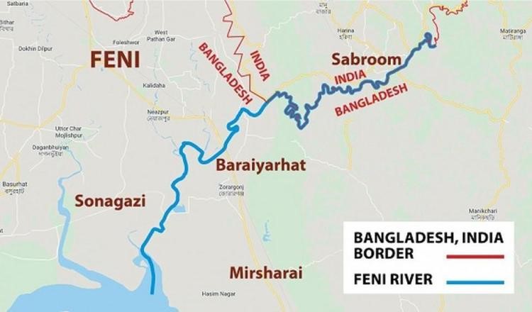
Among these rivers is the Gomti River, which begins at Dumboor Lake in Tripura (just north of the Khagrachari border) and travels over 120 kilometers through Tripura before entering the Comilla district in Bangladesh.
From there, it flows north of Comilla city, passing through Burichong Upazila, Muradnagar, and Gauripur, eventually merging into the Upper Meghna River. In 1976, the Indian government built the Dumboor Dam, a hydroelectric facility, three kilometers downstream from the Gomti River's source at Dumboor Lake.
The Dumboor Dam is significantly smaller than Bangladesh's Kaptai Dam. It stands at 30 meters high, has a power generation capacity of 15 megawatts, and features three spillways or emergency gates.
In contrast, the Kaptai Dam is 45 meters high, has a power generation capacity of 230 megawatts, and has 16 spillways or emergency gates.
We have to understand that a hydroelectric dam functions as a high wall across a river, storing upstream water during the monsoon and releasing it through turbines for year-round electricity generation.
However, if the reservoir's water level surpasses its designed capacity, the excess water must be discharged through spillways or emergency gates integrated into or located near the dam. Some dams are equipped with automatic spillways or emergency gates that open in response to water pressure.
It's crucial to comprehend that only excess water from upstream is released when the reservoir is full, not the entire reservoir's contents. If this excess water isn't released and the gates remain closed, the dam could rupture, leading to a catastrophic release of the entire reservoir's water and causing widespread devastation downstream.
Therefore, releasing excess water through spillways or emergency gates is a standard procedure when the reservoir reaches capacity.
Dumboor Dam opening and lack of information exchange
Last September, additional water from upstream caused Bangladesh's Kaptai Reservoir to reach its maximum level. All 16 spillway gates of the Kaptai Dam had to be opened to discharge the excess water into the Karnafuli River.
On August 25, the water level in the Kaptai Reservoir neared its maximum of 109 feet (above sea level), reaching 108 feet, requiring all 16 gates to be opened.
After releasing some water, the reservoir level decreased below the designed level, allowing the gates to be closed again after six hours.
Let's now address the impact of opening two emergency gates of India's Dumboor Dam on the ongoing flood. Indian authorities state that the maximum capacity of the Dumboor Dam reservoir on the Gomti River is 94 meters (above sea level).
Due to intense upstream rainfall, the water level in the reservoir surpassed its maximum capacity, triggering two out of the three gates to automatically open under pressure, allowing water to flow downstream.
This water, after traveling 120 kilometers through Indian territory, entered Bangladesh. Although some allege that the dam authorities deliberately opened the two emergency gates, the fact remains that the water released from this relatively small dam is not responsible for the widespread flooding across 11 districts in Bangladesh.
The additional water from the Dumboor Dam's emergency gates only entered Bangladesh via the Gomti River and is insignificant compared to the scale of the current flood.
Moreover, among the other 14 rivers flowing from Tripura into Bangladesh, which have been carrying substantial mountain runoff for days, there's no evidence of dam-related activities or gate openings impacting them.
Notably, the worst flooding has hit the Feni district, but the two rivers entering Bangladesh from Tripura at the Feni border - Muhuri and Feni - have no connection to the Dumboor Dam or the Gomti River.
It's important to highlight that Bangladesh and India have a water level information exchange agreement for several rivers. India regularly shares water level data for transboundary rivers, aiding Bangladesh's flood forecasting models.
However, despite the automatic or deliberate opening of the Dumboor Dam's two emergency gates, this information was not communicated to Bangladesh. International water law mandates the upstream country to inform the downstream country about such dam-related events or potential breaches.
This allows the downstream country to anticipate floods and evacuate affected areas in a timely manner. In this instance, the failure to share this information lies with India.
What lies ahead for us?
There is no doubt that the widespread flooding plaguing several districts in India's Tripura state and Bangladesh's eastern and southeastern regions is most severe in Feni and Comilla.
This flood is primarily attributed to the region's geography and topography, the state of the rivers, abnormally heavy rainfall, cloud bursts, and exceptionally high tides due to the full moon.
While the release of water from the Dumboor Dam had a negligible effect on the severe flooding, the lack of communication from India regarding this action hindered flood management efforts in Bangladesh, even though the impact was minor. This failure to inform constitutes a breach of international law.
For years, India has unilaterally built dams and barrages on shared rivers, diverting water during dry seasons without considering Bangladesh, a clear breach of international water laws.
Bangladesh's plan for the Ganges Barrage on the Ganges River in Rajbari District to manage dry-season water remains unrealized due to Indian objections. This project could have significantly mitigated salinization and desertification in the southwest, including the Sundarbans, by storing and distributing Ganges water through the Gorai and other rivers.
The 1996 Ganges Treaty envisioned water agreements for the remaining 53 shared rivers, but India's non-cooperation has prevented any agreement in 28 years.
While both countries approved a Teesta River water agreement draft in 2011, India's government hasn't signed due to West Bengal's objections.
This lack of agreement allows India to unilaterally divert Teesta water via the Gajoldoba Barrage, leaving Bangladesh's Teesta Barrage irrigation project dry and severely impacting groundwater and the environment. Discussions on the Teesta River Master Plan for dredging and embankment construction remain stalled.
Given the current situation, Bangladesh needs to shed its past passivity and adopt a proactive stance to secure its rightful share of water. This can be achieved through enhanced diplomatic relations with India (hydro-diplomacy) and, if required, by invoking international laws and seeking support from organizations like the United Nations.
The people of Bangladesh expect this from both the present interim government and any future democratically elected government formed through a fair and credible process.
—-
Dr Md Ataur Rahman is a Professor of Water Resource Engineering Department of BUET